


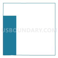
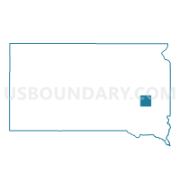
VTD-precinct 5, Miner County, South Dakota
About
Outline

Summary
| Unique Area Identifier | 667578 |
| Name | VTD-precinct 5 |
| County | Miner County |
| State | South Dakota |
| Area (square miles) | 108.22 |
| Land Area (square miles) | 107.42 |
| Water Area (square miles) | 0.80 |
| % of Land Area | 99.26 |
| % of Water Area | 0.74 |
| Latitude of the Internal Point | 43.97436650 |
| Longtitude of the Internal Point | -97.77942890 |
Maps

Graphs
Select a template below for downloading or customizing gragh for VTD-precinct 5, Miner County, South Dakota


Neighbors
Neighoring Voting District (by Name) Neighboring Voting District on the Map
- VTD-precinct 1, Sanborn County, SD
- VTD-precinct 3, Hanson County, SD
- VTD-precinct 4, Hanson County, SD
- VTD-precinct 4, Miner County, SD
- VTD-precinct 6, Miner County, SD
- VTD-precinct 8, Miner County, SD
Top 10 Neighboring County Subdivision (by Population) Neighboring County Subdivision on the Map
- Fairview township, Hanson County, SD (162)
- Plano township, Hanson County, SD (101)
- Clinton township, Miner County, SD (82)
- Rock Creek township, Miner County, SD (78)
- Roswell township, Miner County, SD (58)
- Ravenna township, Sanborn County, SD (53)
- Diana township, Sanborn County, SD (52)
- Green Valley township, Miner County, SD (51)
- Afton township, Sanborn County, SD (44)
- Beaver township, Miner County, SD (40)
Top 10 Neighboring Place (by Population) Neighboring Place on the Map
Top 10 Neighboring Unified School District (by Population) Neighboring Unified School District on the Map
- Mitchell School District 17-2, SD (18,417)
- Howard School District 48-3, SD (2,375)
- Hanson School District 30-1, SD (1,854)
- Sanborn Central School District 55-5, SD (1,215)
Top 10 Neighboring State Legislative District Lower Chamber (by Population) Neighboring State Legislative District Lower Chamber on the Map
Top 10 Neighboring State Legislative District Upper Chamber (by Population) Neighboring State Legislative District Upper Chamber on the Map
Top 10 Neighboring 111th Congressional District (by Population) Neighboring 111th Congressional District on the Map
Top 10 Neighboring Census Tract (by Population) Neighboring Census Tract on the Map
- Census Tract 9641, Hanson County, SD (3,331)
- Census Tract 9616, Miner County, SD (2,389)
- Census Tract 9621, Sanborn County, SD (2,355)
Top 10 Neighboring 5-Digit ZIP Code Tabulation Area (by Population) Neighboring 5-Digit ZIP Code Tabulation Area on the Map
- 57311, SD (1,616)
- 57349, SD (1,493)
- 57314, SD (734)
- 57321, SD (388)
- 57340, SD (355)
- 57323, SD (215)
- 57337, SD (140)